From eRepublik Official Wiki
Pohja-Eesti
 Estonia
 
|
|
Geography
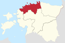
Põhja-Eesti is situated on the northern coast of Estonia, along the Gulf of Finland and covers the historic Harjumaa region, including the capital Tallinn. The length of the coastline is aproximately 320 km and includes several peninsulas. The region has a number of islands, such as Naissaar, Prangli and Aegna close to Tallinn and the Pakri islands close to Paldiski. Most of the region is located on the flat North Estonian Plateau. The region comprises only one county, Harju, formed during the 1990 administrative reform.
Põhja-Eesti possesses 34 rivers and other bodies of water. The longest rivers are the Keila (115 km), Pirita (105 km) and Jägala (97 km). The Keila, Jägala, Valgejõgi and Loobu rivers form picturesque waterfalls on descending from the North Estonian Plateau. Karst areas are widespread. Lakes number 100, with the biggest situated on the coastal plain. The major part of the Suursoo mire is situated in Põhja-Eesti.
Location
Pohja-Eesti is neighbored by the following regions:

