Difference between revisions of "Istria and Kvarner"
(update) |
(update) |
||
| Line 1: | Line 1: | ||
{{LangMenu}} | {{LangMenu}} | ||
| − | {{Region | + | {{Region |
| − | + | |name = Istria and Kvarner | |
| − | + | |link = Istria-Kvarner | |
| − | link=Istria-Kvarner| | + | |altname1 = |
| − | + | |altname2 = | |
| − | number=626 | + | |altname3 = |
| − | coatofarms=Coat-Istria and Kvarner.gif | + | |country = Croatia |
| − | map=Region-Istria and Kvarner.png | + | |number = 626 |
| + | |coatofarms = Coat-Istria and Kvarner.gif | ||
| + | |map = Region-Istria and Kvarner.png | ||
| − | + | <!-- Society --> | |
| − | + | |capital = Rijeka | |
| + | |residents = 132 | ||
| + | |visitors = 207 | ||
| + | |language = Croatian | ||
| + | |movingzone = B3 | ||
| + | |last update = March 9, 2018 | ||
| − | + | <!-- Productivity --> | |
| − | + | |resource1 = | |
| − | + | ||
| − | + | ||
| − | + | ||
}} | }} | ||
| Line 23: | Line 27: | ||
'''Rijeka''' (Italiano and Magyar: ''Fiume'', Deutsch: ''Sankt Veit am Flaum or Pflaum'') is the principal seaport of [[Croatia]], located on Kvarner Bay, an inlet of the Adriatic Sea. | '''Rijeka''' (Italiano and Magyar: ''Fiume'', Deutsch: ''Sankt Veit am Flaum or Pflaum'') is the principal seaport of [[Croatia]], located on Kvarner Bay, an inlet of the Adriatic Sea. | ||
| − | == | + | == Neighbours == |
{{Neighbors|Inner Carniola|Lika and Gorski Kotar|Lower Carniola|Slovenian Littoral}} | {{Neighbors|Inner Carniola|Lika and Gorski Kotar|Lower Carniola|Slovenian Littoral}} | ||
| − | ==Resources== | + | == Resources == |
| − | This region | + | This region formerly had [[File:Icon - Oil.png|35px]] '''[[Oil]]''', and before that it had [[File:Icon - Limestone.png|35px]] '''[[Limestone]]'''. Currently there is no resource in the region. |
| − | == | + | ==Constructions== |
In the region today there is no buildings, but in the past here you could find:<br> | In the region today there is no buildings, but in the past here you could find:<br> | ||
[[File:Icon - Hospital.jpg]]{{Q|3}} | [[File:Icon - Hospital.jpg]]{{Q|3}} | ||
[[File:Icon - Defense System.jpg]]{{Q|5}} | [[File:Icon - Defense System.jpg]]{{Q|5}} | ||
| + | |||
{{Regions|{{BASEPAGENAME}}}} | {{Regions|{{BASEPAGENAME}}}} | ||
| − | |||
Revision as of 07:03, 9 March 2018
| Languages: | ||||||||||||||||||||||||||||||||||||||||||||||||||||||||||||||||||||||||||||||||||||||
| ||||||||||||||||||||||||||||||||||||||||||||||||||||||||||||||||||||||||||||||||||||||
  | |||||||||||||||||
 | |||||||||||||||||
|
Last update: March 9, 2018 |
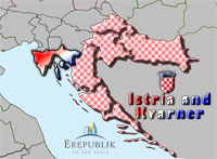
Istria and Kvarner (Hrvatski: Istra i Kvarner) is the westernmost region of Croatia which includes the Istrian peninsula, the biggest Croatian peninsula and Kvarner islands.
Rijeka (Italiano and Magyar: Fiume, Deutsch: Sankt Veit am Flaum or Pflaum) is the principal seaport of Croatia, located on Kvarner Bay, an inlet of the Adriatic Sea.
Neighbours
Istria and Kvarner is neighbored by the following regions:
 Bosnia and Herzegovina, Inner Carniola
 Croatia, Lika and Gorski Kotar
 Slovenia, Lower Carniola
 Lithuania, Slovenian Littoral
Resources
This region formerly had ![]() Oil, and before that it had
Oil, and before that it had ![]() Limestone. Currently there is no resource in the region.
Limestone. Currently there is no resource in the region.
Constructions
In the region today there is no buildings, but in the past here you could find:
![]()
![]()
![]()
![]()
| Regions of |
|---|
|
Albanian Coast · Central Croatia · Central Montenegro · Istria and Kvarner · Lika and Gorski Kotar · Montenegrin Coast · North Dalmatia · Northwest Croatia |